


Tropical Storm Arthur isn’t just ‘bearing down’ – it’s a rapidly intensifying threat, a direct hit poised to unleash life-threatening impacts across the central Gulf Coast. Millions are on high alert, and make no mistake, this system is no joke; it’s a formidable opponent demanding immediate attention and a robust defensive strategy.
The National Hurricane Center (NHC) confirmed Arthur’s rapid formation in the central Gulf of Mexico on June 15th, a swift development that immediately triggered widespread alerts for residents in Louisiana and Mississippi. This isn’t a slow build-up; it’s a quick strike requiring an equally quick response.
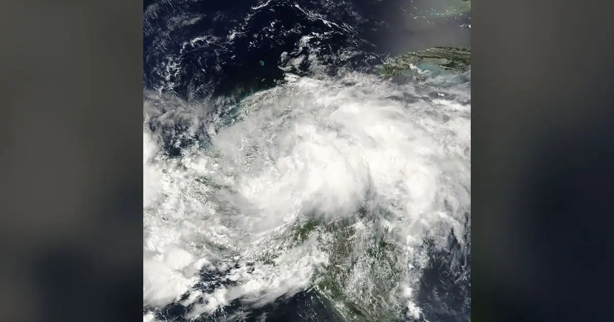
Arthur currently hovers about 250 miles south-southeast of New Orleans, tracking northwest at a steady 10 miles per hour. While sustained winds are presently at 35 mph – just shy of the tropical storm threshold – forecasters are unequivocal: slow intensification is expected, meaning Arthur is gearing up to cross that critical line and unleash its full potential. The window for preparation is closing fast.
Coastal Communities: Preparing for the Knockout Blow
A Tropical Storm Watch blankets the entire Louisiana coast, stretching from Intracoastal City eastward to the Mississippi-Alabama border. This expansive watch includes the vital New Orleans metropolitan area and the vulnerable shores of Lake Pontchartrain. This isn’t a drill; it’s a full-scale defensive posture for a region all too familiar with the brutal realities of hurricane season.
Mississippi’s coastal counties are equally under the gun. Hancock, Harrison, and Jackson counties face the same Tropical Storm Watch, signaling a serious threat to their communities and infrastructure. The message is clear: the storm’s path is undeniable, and its impacts will be felt across this entire coastal stretch.
The primary threats from Tropical Storm Arthur are not ambiguous; they are the game-changers that consistently deliver devastation: excessive rainfall and a dangerous storm surge. These aren’t just weather terms; they are direct threats to life and property.
Forecast models predict widespread rainfall totals that demand immediate action. Southern Louisiana and Mississippi should brace for 4 to 8 inches of rain, with isolated areas facing a catastrophic deluge of up to 12 inches.
This isn’t just heavy rain; this is a recipe for major flash flooding. Such deluges are capable of overwhelming urban drainage systems, turning streets into rivers, and inundating homes. Our bayous and river systems are especially vulnerable, poised to overflow their banks.
Adding to the peril, the storm surge forecast is a critical concern. It calls for 1 to 3 feet above normal tide levels.
This surge will hit watch areas hard, pushing water inland, particularly into bays, inlets, and low-lying coastal areas. For communities already at sea level, even a few feet can mean the difference between minor flooding and structural damage.
Governors Mobilize: A Call to Action from the Top
Emergency management teams across both states are not just ‘in motion’; they are executing their preparedness protocols with tactical precision. This is the kind of decisive, proactive leadership required when a storm like Arthur looms.
“This is a stark reminder that hurricane season is here, and we must remain vigilant,” Louisiana Governor John Bel Edwards stated, his words underscoring the immediate danger.
Governor Edwards didn’t hesitate, declaring a state of emergency for several key coastal parishes. This decisive move mobilizes state resources, including the National Guard and State Police. These forces will assist with evacuations, rescue operations, and post-storm recovery.
He issued a direct command to residents: finalize your hurricane plans now. Even a system that appears weak on the radar can unleash devastating damage, especially through relentless rainfall and unexpected surge.
Mississippi Governor Tate Reeves echoed these urgent warnings, stressing the absolute importance of heeding local advisories. This isn’t a suggestion, folks; it’s a directive. Ignoring these warnings is a gamble with potentially fatal consequences.
“Our coastal communities are resilient, but preparedness is paramount,” Governor Reeves remarked, emphasizing the collective responsibility to protect lives and livelihoods.
He confirmed robust coordination with federal and local partners, ensuring a unified front for rapid response should conditions worsen. This isn’t just about individual safety; it’s about protecting the entire team, the entire community, from the storm’s wrath.
An Active Season Ahead: Arthur’s Ominous Opening Kickoff
Tropical Storm Arthur’s early formation sends an unmistakable message: the 2026 Atlantic Hurricane Season is not just expected to be active; it’s already proving to be so. This is merely the opening kickoff in what promises to be a challenging season, a stark warning of what’s to come.
Leading meteorological agencies are in agreement, their predictions painting a grim outlook. Both the National Oceanic and Atmospheric Administration (NOAA) and Colorado State University (CSU) have forecast a significantly above-average season, releasing updated predictions in late May and early June that point towards an elevated risk. Arthur is merely confirming their analysis.
Why such a grim outlook? The science is clear. Unusually warm Atlantic Ocean temperatures are a primary catalyst, providing abundant fuel for tropical cyclone development. Furthermore, a potential shift towards La Niña conditions plays a crucial role. La Niña typically reduces wind shear across the Atlantic basin, creating a more favorable environment for storms to not only form but also to rapidly intensify. Arthur is a direct, undeniable consequence of these formidable atmospheric and oceanic conditions.
The Federal Emergency Management Agency (FEMA) is not just ‘monitoring the situation’; it’s actively engaged. Regional liaisons are in constant contact with state operations centers, ensuring seamless communication and coordination. FEMA resources – including search and rescue teams, generators, emergency supplies, and logistical support – are on standby, ready to deploy at a moment’s notice. This isn’t just a state effort; it’s a national commitment to safeguarding communities.
Preparation is Key: Your Game Plan for Survival
Local municipalities are issuing direct orders, and residents must comply without hesitation. If you are in a flood-prone area, secure all loose outdoor items now – anything that can become a projectile in high winds. Clear storm drains immediately to mitigate potential flooding. Most critically, have a comprehensive evacuation plan ready, including designated routes and meeting points. Do not wait for mandatory orders; understand your risks and be prepared to move. Listen to local officials; their advisories are your lifeline.
The threat from Tropical Storm Arthur is not theoretical; it is a palpable, immediate danger that demands continued vigilance. This system is tracking relentlessly towards the U.S. coastline, and the potential for widespread disruption is significant. The energy sector in the Gulf, a critical national asset, is under close watch, as a direct hit could have far-reaching economic consequences. This storm has the capacity to hit hard, both physically and economically.
Arthur isn’t waiting for the final whistle. This isn’t merely a weather update; it’s a direct command to action. The clock is ticking – get your game plan locked down, or face the consequences.
Source: Google News