










Satellite Images Reveal Catastrophic Meltdown in Nepal — Climate Change’s Deadly Toll on the Himalayas
Glaciers in Nepal are vanishing at an alarming pace, unleashing floods and landslides that threaten millions. Satellite photos show a stark reality: climate change is tearing apart the Himalayas and endangering local communities.
The Evidence Is Clear and Urgent
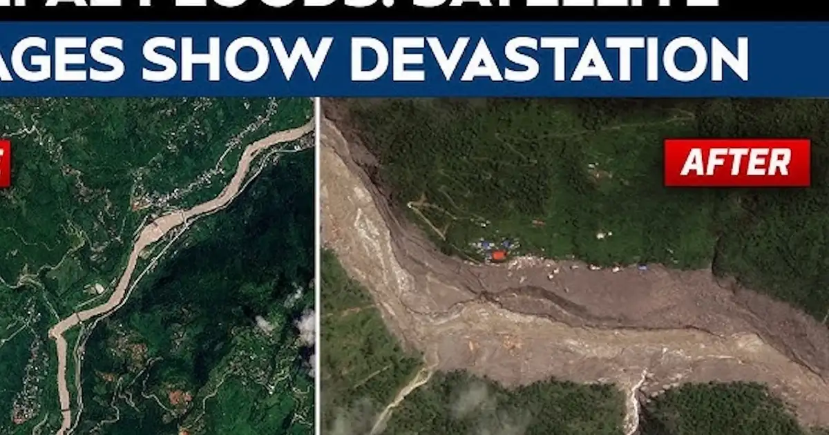
Recent satellite imagery from NASA’s Landsat 8 and Maxar satellites captures a devastating glacier collapse in Nepal’s Langtang Valley. The event triggered a flood that destroyed homes, farmland, and entire villages. This isn’t isolated—it’s part of a growing crisis driven by rising temperatures.

Key facts include:
- Since August 26, about 2.5 km² of glacier ice in Langtang has disappeared—roughly 350 football fields.
- The floodwaters now cover over 150 km², threatening more than 20 villages.
- At least 10 mountain slopes show signs of landslides, blocking routes and hampering rescue efforts.
Images from late August reveal flooded valleys, landslide scars, and submerged fields—visual proof of ongoing destruction. Active threats suggest more damage is imminent.
Why This Is a Wake-Up Call, Not Just a Natural Disaster
This isn’t just a freak weather event; it’s a sign that climate change is melting Himalayan glaciers rapidly. These glaciers feed rivers vital to hundreds of millions downstream. Their collapse risks devastating floods.
The 2014 Langtang GLOF claimed lives and caused millions in damages. Today’s satellite data shows glaciers shrinking faster—2.5 km² lost in days. This isn’t environmental deterioration; it’s a ticking time bomb.
Scientists warned that rising temperatures accelerate melt. Now, satellite images confirm these predictions. Without intervention, floods and landslides will worsen. Climate change has become a current catastrophe, unfolding in real-time.
The Human Cost and What Lies Ahead for Nepal
Hospitals in Kathmandu are overwhelmed with flood victims suffering waterborne diseases and injuries. Infrastructure—roads, bridges, communication—is damaged or destroyed, blocking rescue efforts and isolating villages. If trends continue, Nepal’s fragile infrastructure will collapse under climate pressure.
The upheaval threatens health, food security, and stability. Melting glaciers risk droughts, crop failures, and more floods. Ignoring this crisis could turn Nepal’s mountains into zones of disaster, where ice gives way to chaos.
Satellite Technology: Nepal’s New Early Warning System
Satellite monitoring is becoming vital for Nepal’s disaster response. The government’s new programs track glacier health and predict GLOFs. International agencies like NASA and the UN provide tools for hazard modeling and timely evacuations.
This shift toward proactive management is a breakthrough. Instead of reacting after disasters, Nepal uses space tech to stay ahead. But if global warming persists, these efforts may be futile—the glaciers melt faster than we can respond.
The Real Villain: Global Inaction and Greed
The true culprit isn’t just nature—it’s a global political system that refuses decisive climate action. While satellite images reveal devastation, world leaders remain paralyzed, prioritizing profits over planetary health. Millions in Nepal are paying the price.
Climate change is man-made, and satellite data makes that undeniable. The Himalayan glaciers are the canary in the coal mine—ignore them, and the warning signs will turn into irreversible scars on Earth.
Wake Up Before It’s Too Late
Satellite images serve as a stark warning. The Himalayas are losing ice, and Nepal’s communities drown in floods and despair. This isn’t just climate change; it’s an unfolding disaster. How many villages must be lost before the world acts?
The evidence is clear: glaciers melt, floods surge, and millions are at risk. The moment to act isn’t tomorrow—it’s now. Otherwise, these images will become a permanent record of destruction, not just in Nepal but worldwide. The future depends on our response.
Photo: Vyacheslav Argenberg
Source: Google News